
Two different things with one name
The phrase covers two claims that are usually run together and should not be, because they concern sites eighteen miles apart and evidence of entirely different kinds.
The first is the anomaly proper: a shape in the ice near the summit of Mount Ararat, recorded from the air by the United States Air Force in 1949 and photographed again over the following four decades.
The second is Durupınar, a boat-shaped formation in the foothills near Doğubayazıt, which has been promoted since 1977 as the Ark itself.
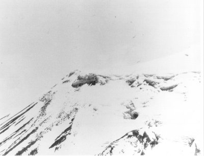
The 1949 reconnaissance frame. The resolution is the point: a linear smudge in ice at fifteen thousand feet is precisely the kind of image a viewer can map an expectation onto. Wikimedia Commons — Public domain

The anomaly
In 1949 a reconnaissance flight over Ararat photographed something protruding from the glacial ice cap at around fifteen and a half thousand feet. The frames were classified, and more were taken in 1956, 1973, 1976, 1990 and 1992.
An intelligence analyst, George J. Stephens, examined them and recorded what remains the only substantive observation anybody has made from the imagery: that the shape read as more linear than the craggy terrain around it.
That is a real observation and it is also as far as the pictures go. The sensors of the period produced grainy results at that range, and a grainy image of a linear feature in ice is precisely the sort of object onto which a viewer can map whatever they came looking for. The anomaly's history since has largely been people doing that.
What the classification actually means
The cover-up version holds that the imagery was withheld because of what it showed.
The imagery was withheld, and that part is true. It was also classified because it was taken by military reconnaissance aircraft and later satellites over the Soviet border during the Cold War, where the sensitive thing in a photograph is not the mountain but the demonstration of what the camera could resolve from where it was flying. Ararat sits within a few miles of what was then the Soviet frontier.
And the imagery was released. A programme that classifies something to conceal an archaeological discovery does not then declassify it in response to requests. What the released frames show is a shape that could be a structure, and could be ice and rock, which is where the matter has stayed.
Durupınar
The lower site is a different proposition, because it can be walked on.
It is a boat-shaped outline in the earth, photographed by a Turkish pilot in 1959 and taken up in 1977 by Ron Wyatt, an amateur explorer who spent years promoting it and conducting his own surveys. The outline is genuinely striking: roughly the proportions given for the Ark in Genesis, and genuinely ship-like from the air.
Turkish geological investigation concluded that it is a natural formation — a feature produced by the movement of mud and rock over a resistant core, of a type that occurs elsewhere in the region. An official examination reported no visible archaeological remains and described it as a freak of nature rather than anything made.
The man who wrote the book, and then wrote the paper
The strongest evidence against Durupınar did not come from a sceptic. It came from its most committed promoter.
David Fasold was a US Merchant Marine officer and marine salvage expert. When he first saw the formation he said aloud that it was a shipwreck, measured it at 538 feet, and set that against the cubits given in Genesis. In 1988 he published The Ark of Noah, an account of his expeditions there. For years he was among the people most responsible for the claim being taken seriously at all.
Then he kept working, and changed his mind.
By September 1994 he was describing it as possibly the oldest running hoax in history — that what had been found was what the ancients had called the Ark, and that it was not the Ark. In 1996 he co-authored a peer-reviewed paper in the Journal of Geoscience Education with the geologist Lorence Collins, titled Bogus "Noah's Ark" from Turkey Exposed as a Common Geologic Structure. Giving evidence in court in April 1997, he dismissed the claim in considerably blunter language.
That paper is worth reading for its method rather than its conclusion. It takes the claimed artefacts one at a time and gives each a mineralogical answer. The iron bracket is weathered volcanic mineral. The metal-braced walls are natural concentrations of limonite and magnetite in steeply inclined sedimentary layers. The fossilised gopherwood bark is metamorphosed peridotite. The anchor stones are local andesite. The formation itself is a doubly plunging syncline — a downfold of sedimentary rock whose outline erosion has cut into roughly the shape of a hull.
The detail that does the most work
Fasold is not the only one who looked and declined. The pattern repeats with the people who went searching alongside him.
Wyatt spent the 1980s trying to interest other ark hunters in the site. Two of the people he approached were James Irwin, the Apollo 15 astronaut who devoted much of his later life to searching Ararat for the Ark, and John D. Morris, a creationist geologist with every reason to want the find to be real.
Neither was convinced.
When the people most motivated to accept a discovery examine it and decline, that is a more informative result than a sceptic's rejection. They were not defending a consensus. They were looking for the same thing and did not think this was it.
Where it stands
No physical evidence of the Ark has been recovered from Mount Ararat or anywhere else. No expedition has produced a sample, a timber, a fitting or a surveyed structure that survived examination.
What exists is a linear smudge in classified-then-released reconnaissance imagery, which is consistent with a structure and equally consistent with ice, and a natural landform eighteen miles away that looks like a boat from above. Neither has produced anything further in seventy-five years of looking, and the people doing the looking have included believers with aircraft, funding and every incentive to find something.